South Eastern Europe from space, you can see the distinctive Italian boot shaped mainland, kicking Sicily. To the right is the Adriatic Sea and Albania, i think we all know what country comes next.
You can just see a glimps of Mala Prespa in the end of that picture aswell. i was talking to my grandmother and she was telling me how the men would use the soft spongy bill parts of the pelicans that lived there to make their drums and sometimes to carry water back to the villiage.
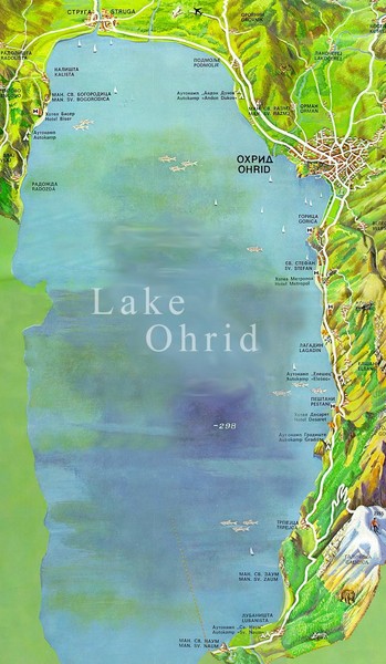
Here is just a little on Ohrid
Lake Ohrid is large (A ~358 km2), deep (maximal depth zmax ~289 m) and one of the most voluminous (volume V ~55 km3) lakes in Europe, with two-thirds in Macedonia and one-third in Albania. Including the underground karst connection to upstream Lake Prespa (A ~254 km2, zmax ~48 m, V ~3.6 km3), the watershed of Lake Ohrid extends into Greece. The overall karst groundwater inflow contributes more than 50 % to the lake’s water balance.
While a groundwater-fed, large water body in Mediterranean climate is exceptional in itself, the most outstanding quality of Lake Ohrid is its endemism (> 200 species). During the two to five million years of existence, species covering the whole food chain have evolved or persisted in the lake. Given its importance as a global hotspot of biodiversity and being the only ancient, long-lived lake in Europe, Lake Ohrid was declared a UNESCO world heritage site in 1979. Here on this Map you can see the deepest part of Lake
Here are some awesome video Clips on how to see Ohrid Lake from above


Leave a comment: